BU geologist El-Baz digs deeper into Darfur conflict
David Cogger
It’s unusual for geologists to have an impact on an international crisis. But then again, Farouk El-Baz is not your usual geologist.
El-Baz is a professor at Boston University and the director of its Center for Remote Sensing, where the latest in satellite and radar imagery is being used to map and classify earth, lunar and Martian surfaces.
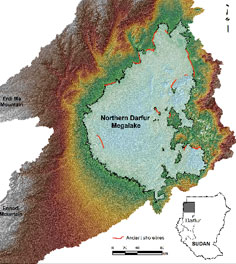
El-Baz’s desert research has led to the recent discovery of an underground lake in the Darfur region of Sudan.
The 11,873-square-mile lake is roughly the size of Massachusetts. Lying beneath a former highland lake, El-Baz theorizes the water has sunk into the sand and become part of the groundwater.
El-Baz also believes that water is the root of much of the conflict between nomads and sedentary farmers that have plagued Darfur since 2003 and have resulted in the deaths of more than 200,000 people.
Over the last 20 years, Darfur has suffered two seven-year droughts. With a new source of water, such as the underground lake, the nomads could support their lifestyle and sedentary farming communities would be able to increase food production using irrigation.
Egypt will drill the first 20 wells in Darfur, and a United Nations mission to the region will require additional wells to support their activities. El-Baz recently met with U.N. Secretary-General Ban Ki-moon to explain the steps required to get to the water.
“I told him about the Sudanese initiative for 1,000 wells for Darfur. He will continue to seek my advice for the selection of sites for U.N. forces and the local population,” El-Baz said.
El-Baz will use data gathered from space images, geophysical surveys and “on-the-ground” field analysis to determine the best drilling sites.
Although he is excited about the lake and its potential to relieve some of the distress in Darfur, El-Baz takes issue with the American media — specifically, its apparent lack of interest in the lake.
“The whole thing fascinates the Europeans,” he said. “I’ve had calls from The Economist [magazine] and other European publications. But if it’s not horrendous, if American people are not dying, this event, in the middle of nothing that could create a whole new life, is of little interest to the American media.”
Growing up in Egypt, El-Baz began collecting and classifying objects when he was a young boy. On Boy Scout field trips outside of Cairo, El-Baz collected colorful rocks, storing them in shoeboxes according to color, shape and texture. He even created his own “museum” displaying the treasures discovered on those field trips.
For most of his life, El-Baz has been interested in thinking about the surface of things — and what lies beneath.
“When I was a young kid, I picked up three pictures of people from a magazine that had been discarded,” he said. “The first one was a regular person and underneath it, I wrote, ‘A man with hair.’ The second one was an older bald guy, underneath it, it said, ‘A man with no hair.’ The third guy wore a hat, and I wrote, ‘A man that we don’t know about.’”
According to El-Baz, his three older brothers “laughed like hell about this.”
But his father, an Islamic scholar at an Egyptian university, found more than just amusement in his young son’s hobby; his reaction was more prescient.
“Don’t laugh at him,” his father told the older boys. “It shows that he is an expert classifier.”
El-Baz has also been involved in a number of more “down to earth” pursuits.
In 1995, he was called upon to resolve a dispute about the actual number of participants in the Million Man March on the Mall in Washington, D.C. The Nation of Islam, who organized the event, wanted to register more black voters and increase their involvement in civic activities. They claimed over 1 million people marched on Washington that day.
At the close of the March, the National Park Service estimated attendance at 400,000.
El-Baz and his team of researchers at Boston University used digitized 35-millimeter photographs covering the entire march area to estimate the total number of participants. By counting heads per one-meter square using photographs taken from a number of different angles, they were able to determine how many marchers there were per square-meter.
Where they were unable to count some areas that were too densely packed with participants, El-Baz used a calculation based on the number of people from his team that he could fit into a roped-off square measuring one meter in area. From there, it became a simple matter of addition.
According to El-Baz, the number was 837,000, with a margin of error of plus or minus 20 percent. But even that number is not totally accurate. El-Baz quickly points out that he didn’t receive his assignment until the events of the day were winding down. A significant number of the attendees had left the mall by then and were walking around an area within 10 blocks of the mall.
El-Baz’s earned his current post at Boston University courtesy of the ambitions of John Silber, then the university’s president. In 1986, Silber contacted El-Baz and asked him to set up a remote imaging center at BU.
At first, El-Baz balked at the idea, knowing the university could never match the salary he was making as a corporate vice president. But he agreed to have lunch with Silber just the same.
“I told them that [BU] would be the new kid on the block, so we should not do it the same way as Caltech and Michigan.” The two universities already had well-established remote imaging centers that El-Baz referred to as “mutual admiration societies.”
As El-Baz saw it, BU needed a more open approach so that anybody who wanted to use the technology could do so.
“When Silber asked me what it would take for me to come to BU, I laughed. I told him that if I could travel and work as a consultant to make up for the money I would lose by leaving the corporate world, I might consider it,” he said.
Sounding amused, El-Baz continued, “They gave me everything I wanted.”
Silber knew talent when he saw it.
During his early years working at NASA, El-Baz helped to map the lunar surface for the Apollo missions, selecting landing sites for the lunar module by interpreting photographs taken by astronomical observatories and images from lunar orbiters.
While his colleagues at NASA were interested in finding landing sites ideal for conserving fuel, El-Baz was looking for sites that had “scientific potential.”
“It was clear to me that the astronauts were not very enthused about the science of geology — naming rocks, discovering their chemical formulas. Their mandate was to bring a man to the moon and bring him safely back to earth.” Laughing, El-Baz said, “That mandate didn’t say, ‘Bring back some lunar dirt.’”
So for El-Baz, the challenge at NASA became convincing the astronauts that science was a significant component of the mission.
“Their mentality was that if you’ve seen one rock, you’ve seen them all,” he said.
El-Baz approached this challenge “rather sneakily,” telling the astronauts the public had serious questions about the value of sending people to the moon at such a great cost. He convinced the astronauts that the interaction between the human eye and the brain was something that no computer could handle.
“The astronauts had to know what the scientists on the ground knew so they could add to what [the scientists] didn’t know,” he said.
He began by suggesting the astronauts start looking at the geography of the places they were flying over on their trips between NASA headquarters in Houston and Cape Canaveral in Florida.
He gave the astronauts booklets and asked them to identify specific regions and their geographical features. “I would ask them to describe what they had flown over. I would test them, and, one by one, they became very good at this,” El-Baz said.
El-Baz then had the astronauts transfer the skills they had learned flying at 25,000 feet over the earth to interpreting features of the lunar surface.
He said eventually the astronauts began to compete in their knowledge of the features of the moon.
Apollo 13 astronaut Ken Mattingly was the first to “swallow it,” said El-Baz.
“I knew that I got them [the astronauts] when I had just finished dinner with Mattingly. I was going through the door, and another astronaut asked me if I was Farouk El-Baz.”
“He said, ‘I want you to make me as smart as Ken Mattingly — hell, no, I want you to make me smarter than Ken.’”
Since 1974, El-Baz has been involved in desert research.
Responding to the Arab oil embargo in 1973, the White House asked El-Baz to go on a goodwill mission to ease tensions between the Gulf States and the United States. The State Department arranged for El-Baz to tour the six Gulf States to speak about the moon.
“They took my slides and I gave a lecture on the scientific discoveries in Arabic,” El-Baz said. “The media went crazy, and I met all of the heads of state.”
One of them was Anwar Sadat, president of Egypt, El-Baz’s home country. Sadat told El-Baz that he should start a research project there. El-Baz jumped at the chance and went to his alma mater in Egypt, organizing a team to study desert landforms.
For 17 years, El-Baz studied the desert landscape in Egypt, which he said is almost exactly the same as those of the moon and Mars. Both Mars and Egypt once had water and now the landscapes have been taken over by wind.
“When we began looking at pictures of the Egyptian desert, we said, ‘My God, most of these are identical to Mariner 9 and the Viking missions to Mars,’” El-Baz said. “They share the same geological history.”
|
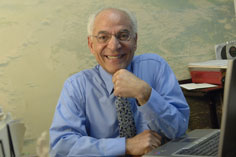
| Farouk El-Baz, professor of geology at Boston University and director of its Center for Remote Sensing, used remote satellite images and field studies to locate an underground lake in the Darfur region of Sudan. (Photo courtesy of Boston University) |
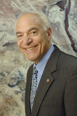
(Top) Before taking a position at Boston University, El-Baz worked with NASA to train their astronauts in lunar geology and was an emissary to the Gulf region during the 1974 oil embargo. (Photo courtesy of Boston University)
(Bottom) El-Baz’s research at BU Center for Remote Sensing discovered an underground lake roughly the size of Massachusetts in northern Darfur. El-Baz believes that the additional water source could help quell tensions in the region. (Photo courtesy of Boston University) |
|